Geolocate

Muggia / Milje topographic map

Click on the map to display elevation.

About this map

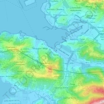
Name: Muggia / Milje topographic map, elevation, terrain.

Location: Muggia / Milje, Trieste, Friuli – Venezia Giulia, 34015, Italy (45.58090 13.71902 45.61080 13.82255)

Average elevation: 47 m

Minimum elevation: -7 m

Maximum elevation: 303 m

Other topographic maps

Click on a map to view its topography, its elevation and its terrain.

Gear up for your next adventure:

🛌Down Sleeping Bag - Superior warmth-to-weight ratio for cold nights
🏕️Camping Hammock - Integrated protection for sleeping between trees
🥾Hiking Leggings - Comfortable leggings for outdoor activities
❄️Traction Ice Cleats - Slip-on spikes for icy trails and winter hiking
Backpacking Tent - Lightweight tent for long-distance hiking trips

As an Amazon Associate, this site earns from qualifying purchases at no extra cost to you.