Geolocate

Vembanur topographic map

Click on the map to display elevation.

About this map

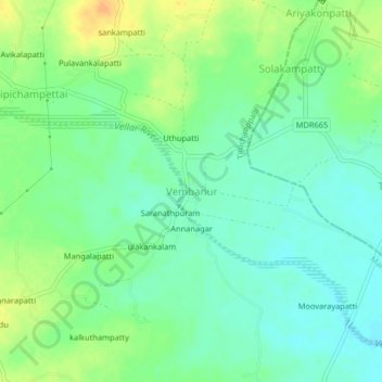
Name: Vembanur topographic map, elevation, terrain.

Location: Vembanur, Manapparai, Tiruchirappalli, Tamil Nadu, India (10.46636 78.54451 10.50636 78.58451)

Average elevation: 149 m

Minimum elevation: 136 m

Maximum elevation: 168 m

Gear up for your next adventure:

Backpacking Tent - Lightweight tent for long-distance hiking trips
🧥Fleece Jacket - Warm and lightweight jacket for layering
🥾Durable Hiking Shoes - Long-lasting shoes for frequent hiking
🥾Trail Hiking Socks - Comfortable socks to prevent blisters and fatigue
Camping Groundsheet - Protect your tent from moisture and dirt

As an Amazon Associate, this site earns from qualifying purchases at no extra cost to you.