
Isla de Mona topographic map
Interactive map
Click on the map to display elevation.
About this map
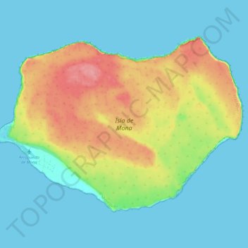
Name: Isla de Mona topographic map, elevation, terrain.
Location: Isla de Mona, Mayagüez, Puerto Rico, United States (18.05297 -67.94586 18.12185 -67.84365)
Average elevation: 26 m
Minimum elevation: -1 m
Maximum elevation: 88 m
Mona is a mainly flat plateau surrounded by sea cliffs. It is composed of dolomite and limestone with many caves found throughout. With an arid climate and untouched by human development, many endemic species inhabit the island, such as the Mona ground iguana (Cyclura cornuta stejnegeri). Its topography, ecology, and modern history are similar to that of Navassa Island, a small limestone island located in the Jamaica Channel, between Jamaica and Haiti.
Other topographic maps
Click on a map to view its topography, its elevation and its terrain.
East Ridge
United States > Puerto Rico > Mayagüez
East Ridge, Sabanetas, Mayagüez, Puerto Rico, United States
Average elevation: 9 m
Juan Alonso
United States > Puerto Rico > Mayagüez
Juan Alonso, Mayagüez, Puerto Rico, United States
Average elevation: 174 m
Guanajibo
United States > Puerto Rico > Mayagüez
Guanajibo, Mayagüez, Puerto Rico, United States
Average elevation: 8 m
Naranjales
United States > Puerto Rico > Mayagüez
Naranjales, Mayagüez, Puerto Rico, United States
Average elevation: 311 m