Geolocate

Aarschot topographic map

Click on the map to display elevation.

About this map

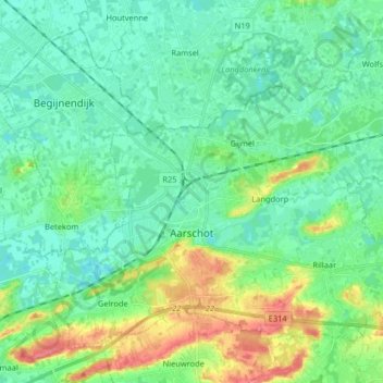
Name: Aarschot topographic map, elevation, terrain.

Location: Aarschot, Leuven, Flemish Brabant, Flanders, Belgium (50.95336 4.77398 51.03752 4.93649)

Average elevation: 22 m

Minimum elevation: 4 m

Maximum elevation: 72 m

Other topographic maps

Click on a map to view its topography, its elevation and its terrain.

Beneden-Kessel

Belgium > Flemish Brabant > Leuven > Leuven > Kessel-Lo

Average elevation: 34 m

Butsel

Belgium > Flemish Brabant > Leuven > Boutersem

Average elevation: 66 m

Stadspark

Belgium > Flemish Brabant > Leuven > Aarschot

Average elevation: 24 m

Ourodenberg

Belgium > Flemish Brabant > Leuven > Aarschot

Average elevation: 16 m

Leuven

Belgium > Flemish Brabant > Leuven > Leuven

Average elevation: 50 m

Hoste

Belgium > Flemish Brabant > Leuven > Diest > Deurne

Average elevation: 28 m

Gear up for your next adventure:

🚑Survival Whistle - Signal for help across long distances in mountains
🧰Emergency Multi-Tool - Compact multi-tool for outdoor survival
🐕Hiking Dog Pack - Let your canine companion carry their own water and food
Bushcraft Tarp - Versatile emergency shelter or gear protection
💧Reusable Water Bottle - Durable water bottles for hydration on trails

As an Amazon Associate, this site earns from qualifying purchases at no extra cost to you.