Geolocate

Moneta topographic map

Click on the map to display elevation.

About this map

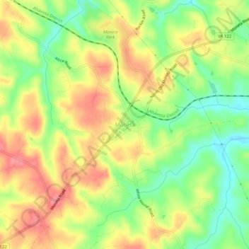
Name: Moneta topographic map, elevation, terrain.

Location: Moneta, Bedford County, Virginia, 24121, United States (37.16058 -79.63994 37.20058 -79.59994)

Average elevation: 273 m

Minimum elevation: 231 m

Maximum elevation: 310 m

Other topographic maps

Click on a map to view its topography, its elevation and its terrain.

Elk Creek

United States > Virginia > Bedford County

Average elevation: 220 m

Bedford

United States > Virginia > Bedford County

Average elevation: 285 m

Gear up for your next adventure:

🧼Biodegradable Camp Soap - Environmentally friendly cleaning for gear and body
🥾Approach Boots - Comfortable boots for hiking and climbing approaches
🧣Evaporative Cooling Towel - Beat the heat during intense summer climbs
🎒Fully Waterproof Backpack - Total protection for photography gear and electronics
🧥Fleece Jacket - Warm and lightweight jacket for layering

As an Amazon Associate, this site earns from qualifying purchases at no extra cost to you.