Geolocate

Longemain topographic map

Click on the map to display elevation.

About this map

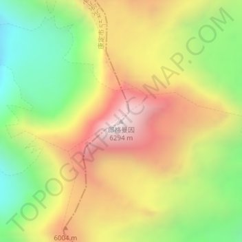
Name: Longemain topographic map, elevation, terrain.

Location: Longemain, Kangding, Kardze, Sichuan, 626000, China (29.65263 101.83783 29.65273 101.83793)

Average elevation: 5,647 m

Minimum elevation: 5,040 m

Maximum elevation: 6,292 m

Other topographic maps

Click on a map to view its topography, its elevation and its terrain.

贡巴冰川

China > Sichuan > Kangding

Average elevation: 5,375 m

康定跑马山风景区

China > Sichuan > Kangding > Jingangsi

Average elevation: 2,804 m

Gear up for your next adventure:

🔦LED Headlamp - Hands-free lighting for early morning starts or late finishes
🧥Thermal Layer - Insulating layer for cold outdoor conditions
🔭Compact Monocular - One-handed bird watching and trail spotting
🛏️Camping Sleeping Mat - Comfortable mats for sleeping outdoors
🥾Trail Running Shoes - Lightweight and durable shoes for trail running

As an Amazon Associate, this site earns from qualifying purchases at no extra cost to you.