
Thank you for supporting this site ❤️
Make a donation
Make a donation
Gear up for your next adventure:
As an Amazon Associate, this site earns from qualifying purchases at no extra cost to you.
Mirabel topographic map
Click on the map to display elevation.
Thank you for supporting this site ❤️
Make a donation
Make a donation
Gear up for your next adventure:
As an Amazon Associate, this site earns from qualifying purchases at no extra cost to you.
Mirabel
El municipio tiene una altitud de 488 msnm y tiene aires de solano, lo cual lo hace frío en invierno y muy caluroso en verano.
Thank you for supporting this site ❤️
Make a donation
Make a donation
Gear up for your next adventure:
As an Amazon Associate, this site earns from qualifying purchases at no extra cost to you.
About this map
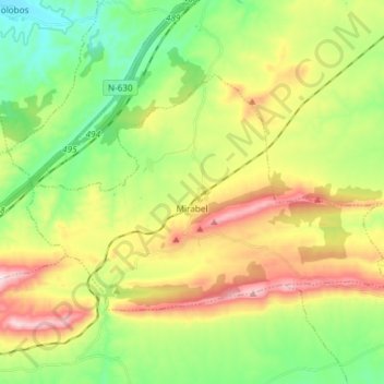
Name: Mirabel topographic map, elevation, terrain.
Location: Mirabel, Monfragüe, Cáceres, Extremadura, 10540, España (39.83119 -6.29806 39.90148 -6.14919)
Average elevation: 450 m
Minimum elevation: 261 m
Maximum elevation: 741 m
Thank you for supporting this site ❤️
Make a donation
Make a donation
Gear up for your next adventure:
As an Amazon Associate, this site earns from qualifying purchases at no extra cost to you.