
Thank you for supporting this site ❤️
Make a donation
Make a donation
Gear up for your next adventure:
As an Amazon Associate, this site earns from qualifying purchases at no extra cost to you.
Ruhstorf topographic map
Click on the map to display elevation.
Thank you for supporting this site ❤️
Make a donation
Make a donation
Gear up for your next adventure:
As an Amazon Associate, this site earns from qualifying purchases at no extra cost to you.
About this map
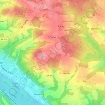
Name: Ruhstorf topographic map, elevation, terrain.
Location: Ruhstorf, Windorf, Landkreis Passau, Bayern, Deutschland (48.62581 13.24427 48.62697 13.24685)
Average elevation: 376 m
Minimum elevation: 297 m
Maximum elevation: 439 m
Thank you for supporting this site ❤️
Make a donation
Make a donation
Gear up for your next adventure:
As an Amazon Associate, this site earns from qualifying purchases at no extra cost to you.