
Brazzaville topographic map
Interactive map
Click on the map to display elevation.
About this map
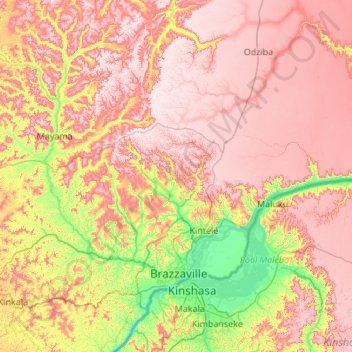
Name: Brazzaville topographic map, elevation, terrain.
Location: Brazzaville, Congo-Brazzaville (-4.51216 14.95375 -3.42823 15.96122)
Average elevation: 519 m
Minimum elevation: 237 m
Maximum elevation: 778 m
Brazzaville is 506 km (314 mi) inland from the Atlantic Ocean and approximately 474 km (295 mi) south of the equator. The city is a commune that is separated from the other regions of the republic; it is surrounded by the Pool Department. Around the city are large plains. The town is relatively flat, and situated at an altitude of 317 m (1,040 ft). Downriver the Congo has numerous rapids, known as Livingston Falls, preventing navigation upriver to this point from its mouth at the Atlantic.
Other topographic maps
Click on a map to view its topography, its elevation and its terrain.
Mbomo
Congo-Brazzaville > Cuvette-Ouest Department
Mbomo, Cuvette-Ouest Department, Congo-Brazzaville
Average elevation: 483 m
Republic of the Congo
Republic of the Congo, Congo-Brazzaville
Average elevation: 429 m
Cuvette-Ouest Department
Cuvette-Ouest Department, Congo-Brazzaville
Average elevation: 453 m