
Make a donation
Gear up for your next adventure:
As an Amazon Associate, this site earns from qualifying purchases at no extra cost to you.
Ashdod topographic map
Click on the map to display elevation.
Make a donation
Gear up for your next adventure:
As an Amazon Associate, this site earns from qualifying purchases at no extra cost to you.
About this map
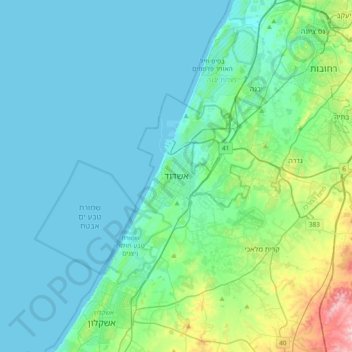
Name: Ashdod topographic map, elevation, terrain.
Location: Ashdod, Ashkelon Subdistrict, South District, 7750502, Israel (31.63773 34.49299 31.95773 34.81299)
Average elevation: 31 m
Minimum elevation: -1 m
Maximum elevation: 200 m
Make a donation
Gear up for your next adventure:
As an Amazon Associate, this site earns from qualifying purchases at no extra cost to you.
Other topographic maps
Click on a map to view its topography, its elevation and its terrain.
Arad
The plan took into account topography and climate, with residential buildings constructed with large inner courtyards that offered protection from the desert sun and wind. High density residential areas were built first in order to create an urban milieu and shorten walking distances.
Average elevation: 579 m
Make a donation
Gear up for your next adventure:
As an Amazon Associate, this site earns from qualifying purchases at no extra cost to you.