Geolocate

Alella topographic map

Click on the map to display elevation.

About this map

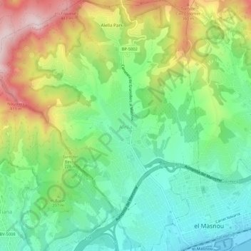
Name: Alella topographic map, elevation, terrain.

Location: Alella, Maresme, Barcelona, Catalonia, 08328, Spain (41.47577 2.26661 41.51532 2.30968)

Average elevation: 171 m

Minimum elevation: -1 m

Maximum elevation: 466 m

Other topographic maps

Click on a map to view its topography, its elevation and its terrain.

el Masnou

Spain > Catalonia > Maresme > el Masnou > el Masnou

Average elevation: 92 m

Palafolls

Spain > Catalonia > Maresme > Palafolls > Palafolls

Average elevation: 26 m

Gear up for your next adventure:

🦌Outdoor Trail Camera - Monitor wildlife activity near your favorite spots
🧴Outdoor Sunscreen - High SPF protection for high-altitude UV exposure
💡Compact LED Flashlight - Powerful and portable flashlight for outdoor use
🛶Kayak Accessories - Essential gear for safe and fun kayaking adventures
💧Reusable Water Bottle - Durable water bottles for hydration on trails

As an Amazon Associate, this site earns from qualifying purchases at no extra cost to you.