
Thank you for supporting this site ❤️
Make a donation
Make a donation
Gear up for your next adventure:
As an Amazon Associate, this site earns from qualifying purchases at no extra cost to you.
Honduras topographic map
Click on the map to display elevation.
Thank you for supporting this site ❤️
Make a donation
Make a donation
Gear up for your next adventure:
As an Amazon Associate, this site earns from qualifying purchases at no extra cost to you.
About this map
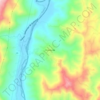
Name: Honduras topographic map, elevation, terrain.
Location: Honduras, Buenos Aires, Norte, Cauca, Colombia (2.97075 -76.69582 3.01075 -76.65582)
Average elevation: 1,154 m
Minimum elevation: 1,005 m
Maximum elevation: 1,413 m
Thank you for supporting this site ❤️
Make a donation
Make a donation
Gear up for your next adventure:
As an Amazon Associate, this site earns from qualifying purchases at no extra cost to you.