
Echeandía topographic map
Interactive map
Click on the map to display elevation.
About this map
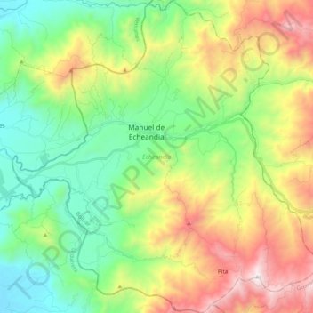
Name: Echeandía topographic map, elevation, terrain.
Location: Echeandía, Bolívar, Ecuador (-1.54199 -79.36123 -1.35198 -79.17607)
Average elevation: 638 m
Minimum elevation: 22 m
Maximum elevation: 1,762 m
Other topographic maps
Click on a map to view its topography, its elevation and its terrain.
Parque Infantil
Ecuador > Bolívar > San Vicente > Ungubí
Parque Infantil, Ciudadela Coloma Armijos, Ungubí, San Vicente, San Miguel, Bolívar, Ecuador
Average elevation: 2,568 m