
Make a donation
Gear up for your next adventure:
As an Amazon Associate, this site earns from qualifying purchases at no extra cost to you.
Terrades topographic map
Click on the map to display elevation.
Make a donation
Gear up for your next adventure:
As an Amazon Associate, this site earns from qualifying purchases at no extra cost to you.
About this map
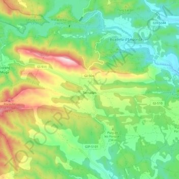
Name: Terrades topographic map, elevation, terrain.
Location: Terrades, Oberampurien, Girona, Katalonien, 17731, Spanien (42.28254 2.78452 42.34123 2.88352)
Average elevation: 219 m
Minimum elevation: 64 m
Maximum elevation: 509 m
Make a donation
Gear up for your next adventure:
As an Amazon Associate, this site earns from qualifying purchases at no extra cost to you.
Other topographic maps
Click on a map to view its topography, its elevation and its terrain.
Montgó
Spanien > Katalonien > Oberampurien > l'Escala
Der Montgó (seltener auch Mongó) ist ein Berg im Südosten Spaniens, im Norden der Costa Blanca, in der Nähe der Küstenstädte Dénia und Xàbia mit einer Höhe von 753 msnm. Der Montgó selbst und das ihn umgebende Gebiet ist Naturschutzgebiet („Parc Natural el Montgó“).
Average elevation: 17 m