
Thank you for supporting this site ❤️
Make a donation
Make a donation
Gear up for your next adventure:
As an Amazon Associate, this site earns from qualifying purchases at no extra cost to you.
Kim Bôi District topographic map
Click on the map to display elevation.
Thank you for supporting this site ❤️
Make a donation
Make a donation
Gear up for your next adventure:
As an Amazon Associate, this site earns from qualifying purchases at no extra cost to you.
About this map
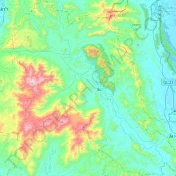
Name: Kim Bôi District topographic map, elevation, terrain.
Location: Kim Bôi District, Hoà Bình province, Vietnam (20.52240 105.36864 20.82859 105.68487)
Average elevation: 260 m
Minimum elevation: -1 m
Maximum elevation: 1,169 m
Thank you for supporting this site ❤️
Make a donation
Make a donation
Gear up for your next adventure:
As an Amazon Associate, this site earns from qualifying purchases at no extra cost to you.