Geolocate

Costa Verde topographic map

Click on the map to display elevation.

About this map

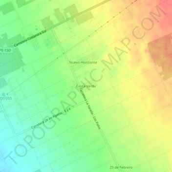
Name: Costa Verde topographic map, elevation, terrain.

Location: Costa Verde, La Yarada-Los Palos, Tacna, Perú (-18.18391 -70.45633 -18.14391 -70.41633)

Average elevation: 110 m

Minimum elevation: 81 m

Maximum elevation: 141 m

Other topographic maps

Click on a map to view its topography, its elevation and its terrain.

La Yarada-Los Palos

Perú > Tacna > La Yarada-Los Palos

Average elevation: 97 m

Gear up for your next adventure:

🧥Ultralight Puffy Jacket - Maximum warmth that packs down to the size of an orange
🔋Solar Power Bank - Keep your GPS and devices charged during long outdoor trips
💡Compact LED Flashlight - Powerful and portable flashlight for outdoor use
🛏️Camping Sleeping Mat - Comfortable mats for sleeping outdoors
🧰Multitool Knife - Compact and versatile tool for outdoor use

As an Amazon Associate, this site earns from qualifying purchases at no extra cost to you.