
Make a donation
Gear up for your next adventure:
As an Amazon Associate, this site earns from qualifying purchases at no extra cost to you.
Looc topographic map
Click on the map to display elevation.
Make a donation
Gear up for your next adventure:
As an Amazon Associate, this site earns from qualifying purchases at no extra cost to you.
About this map
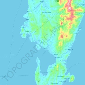
Name: Looc topographic map, elevation, terrain.
Location: Looc, Romblon, Mimaropa, 5507, Philippines (12.18429 121.81166 12.36888 122.04163)
Average elevation: 49 m
Minimum elevation: -1 m
Maximum elevation: 601 m
Make a donation
Gear up for your next adventure:
As an Amazon Associate, this site earns from qualifying purchases at no extra cost to you.
Other topographic maps
Click on a map to view its topography, its elevation and its terrain.
Mount Guiting-Guiting
Philippines > Romblon > Cajidiocan
Mount Guiting-Guiting is the highest mountain in the province of Romblon, located in Sibuyan Island, in the Philippines, with an elevation of 6,752 ft (2,058 m) above sea level. Its steep slopes and jagged peak, have earned it a reputation as one of the most technically challenging mountains to climb in the…
Average elevation: 1,478 m