Geolocate

Bhuntar topographic map

Click on the map to display elevation.

About this map

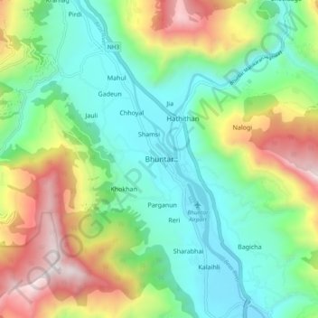
Name: Bhuntar topographic map, elevation, terrain.

Location: Bhuntar, Kullu, Himachal Pradesh, 175126, India (31.84752 77.10362 31.92752 77.18362)

Average elevation: 1,559 m

Minimum elevation: 1,057 m

Maximum elevation: 2,569 m

Gear up for your next adventure:

🛁Quick-Dry Microfiber Towel - Space-saving towel that dries rapidly on the move
🥾Hiking Leggings - Comfortable leggings for outdoor activities
🔭Outdoor Binoculars - Lightweight binoculars for birdwatching and hiking
🥫Freeze-Dried Meals - Lightweight, high-calorie nutrition for multi-day treks
🪜Heavy Duty Carabiners - Multi-use clips for securing gear to your backpack

As an Amazon Associate, this site earns from qualifying purchases at no extra cost to you.