Geolocate

Kuthiathode topographic map

Click on the map to display elevation.

About this map

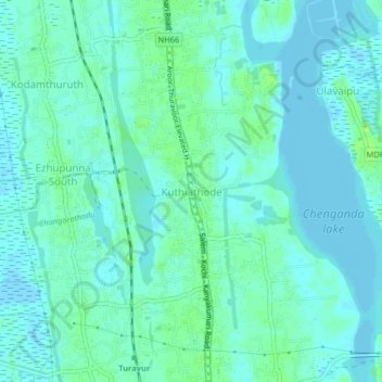
Name: Kuthiathode topographic map, elevation, terrain.

Location: Kuthiathode, Cherthala, Alappuzha, Kerala, 688533, India (9.77234 76.29638 9.81234 76.33638)

Average elevation: 4 m

Minimum elevation: -5 m

Maximum elevation: 12 m

Other topographic maps

Click on a map to view its topography, its elevation and its terrain.

Perumbalam

India > Kerala > Cherthala > Perumbalam

Average elevation: 3 m

Vembanad Lake

India > Kerala > Cherthala > Thaneermukkom

Average elevation: 4 m

Kakkanadu-Thenamara

India > Kerala > Cherthala

Average elevation: 9 m

resort

India > Kerala > Cherthala > Ulavaipu

Average elevation: 4 m

Gear up for your next adventure:

🧦Crew Hiking Socks - Comfortable socks for long-distance hikes
🥤Collapsible Travel Cup - Saves space and weight in your mess kit
🥾Hiking Shoes - Durable and comfortable shoes for trail hiking
💧Collapsible Water Bottle - Space-saving water bottle for outdoor activities
🥫Freeze-Dried Meals - Lightweight, high-calorie nutrition for multi-day treks

As an Amazon Associate, this site earns from qualifying purchases at no extra cost to you.