
Cobalt topographic map
Click on the map to display elevation.
About this map
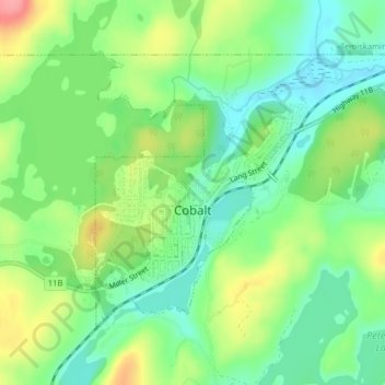
Name: Cobalt topographic map, elevation, terrain.
Average elevation: 312 m
Minimum elevation: 276 m
Maximum elevation: 373 m
Timiskaming District trails, hiking, mountain biking, running and outdoor activities
Other topographic maps
Click on a map to view its topography, its elevation and its terrain.
Henwood Lake
Canada > Ontario > Timiskaming District > Unorganized West Timiskaming
Average elevation: 288 m
Boston Creek
Canada > Ontario > Timiskaming District > Unorganized West Timiskaming
Average elevation: 300 m
Baptiste Creek;Baptiste Lake
Canada > Ontario > Timiskaming District > Unorganized West Timiskaming
Average elevation: 334 m
Flanagan Lake
Canada > Ontario > Timiskaming District > Unorganized West Timiskaming
Average elevation: 403 m
Heart Lake
Canada > Ontario > Timiskaming District > Unorganized West Timiskaming > King Kirkland
Average elevation: 336 m
Kenabeek
Canada > Ontario > Timiskaming District > Unorganized West Timiskaming
Average elevation: 284 m
Hobart Lake
Canada > Ontario > Timiskaming District > Unorganized West Timiskaming
Average elevation: 305 m