
Make a donation
Gear up for your next adventure:
As an Amazon Associate, this site earns from qualifying purchases at no extra cost to you.
Plan-d'Orgon topographic map
Click on the map to display elevation.
Make a donation
Gear up for your next adventure:
As an Amazon Associate, this site earns from qualifying purchases at no extra cost to you.
About this map
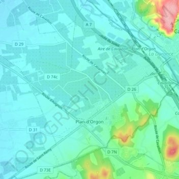
Name: Plan-d'Orgon topographic map, elevation, terrain.
Average elevation: 75 m
Minimum elevation: 54 m
Maximum elevation: 187 m
Make a donation
Gear up for your next adventure:
As an Amazon Associate, this site earns from qualifying purchases at no extra cost to you.
Other topographic maps
Click on a map to view its topography, its elevation and its terrain.
Plan de Campagne
Frankrijk > Provence-Alpes-Côte d'Azur > Bouches-du-Rhône > Les Pennes-Mirabeau
Average elevation: 231 m
Clos Saint-Éloi
Frankrijk > Provence-Alpes-Côte d'Azur > Bouches-du-Rhône > La Ciotat
Average elevation: 108 m
La Ciotat
Frankrijk > Provence-Alpes-Côte d'Azur > Bouches-du-Rhône > La Ciotat > La Ciotat
Average elevation: 57 m
Make a donation
Gear up for your next adventure:
As an Amazon Associate, this site earns from qualifying purchases at no extra cost to you.
Matheron
Frankrijk > Provence-Alpes-Côte d'Azur > Bouches-du-Rhône > Pélissanne
Average elevation: 119 m