Geolocate

Sadri topographic map

Click on the map to display elevation.

Sadri

Sadri is located at 25°11′N 73°26′E / 25.18°N 73.43°E / 25.18; 73.43. It has an average elevation of 502 meters.

Wikipedia (CC-BY-SA 3.0)

About this map

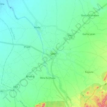
Name: Sadri topographic map, elevation, terrain.

Location: Sadri, Desuri Tehsil, Pali, Rajasthan, 306702, India (25.14665 73.41270 25.22665 73.49270)

Average elevation: 362 m

Minimum elevation: 332 m

Maximum elevation: 455 m

Gear up for your next adventure:

🧴Insect Repellent - Protect yourself from bugs during outdoor adventures
🎒Fully Waterproof Backpack - Total protection for photography gear and electronics
🧭GPS Outdoor Watch - Smart watch for navigation and fitness tracking in nature
🧊Insulated Water Bottle - Keeps drinks cold in summer and prevents freezing in winter
💧Collapsible Water Bottle - Space-saving water bottle for outdoor activities

As an Amazon Associate, this site earns from qualifying purchases at no extra cost to you.