
Thank you for supporting this site ❤️
Make a donation
Make a donation
Gear up for your next adventure:
As an Amazon Associate, this site earns from qualifying purchases at no extra cost to you.
Türkelstein topographic map
Click on the map to display elevation.
Thank you for supporting this site ❤️
Make a donation
Make a donation
Gear up for your next adventure:
As an Amazon Associate, this site earns from qualifying purchases at no extra cost to you.
Türkelstein
Der in der Wiesentalb gelegene Weiler liegt etwa zweieinhalb Kilometer südöstlich des Ortszentrums von Gößweinstein auf einer Höhe von 519 m ü. NHN.
Thank you for supporting this site ❤️
Make a donation
Make a donation
Gear up for your next adventure:
As an Amazon Associate, this site earns from qualifying purchases at no extra cost to you.
About this map
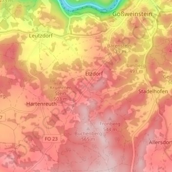
Name: Türkelstein topographic map, elevation, terrain.
Average elevation: 486 m
Minimum elevation: 315 m
Maximum elevation: 561 m
Thank you for supporting this site ❤️
Make a donation
Make a donation
Gear up for your next adventure:
As an Amazon Associate, this site earns from qualifying purchases at no extra cost to you.