Geolocate

Tucumcari topographic map

Click on the map to display elevation.

About this map

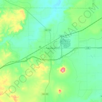
Name: Tucumcari topographic map, elevation, terrain.

Location: Tucumcari, Quay County, New Mexico, 88401, United States (35.13565 -103.80752 35.19758 -103.59149)

Average elevation: 1,263 m

Minimum elevation: 1,184 m

Maximum elevation: 1,513 m

Other topographic maps

Click on a map to view its topography, its elevation and its terrain.

Hudson

United States > New Mexico > Quay County

Average elevation: 1,243 m

House

United States > New Mexico > Quay County

Average elevation: 1,437 m

House

United States > New Mexico > Quay County

Average elevation: 1,437 m

Gear up for your next adventure:

👖Convertible Hiking Pants - Zip-off legs to adapt to changing weather conditions
🥾Trekking Boots - Durable boots for long-distance trekking
🧊Insulated Water Bottle - Keeps drinks cold in summer and prevents freezing in winter
🥾Light Hiking Boots - Lightweight and comfortable boots for day hikes
🧥Thermal Layer - Insulating layer for cold outdoor conditions

As an Amazon Associate, this site earns from qualifying purchases at no extra cost to you.