
Thank you for supporting this site ❤️
Make a donation
Make a donation
Gear up for your next adventure:
As an Amazon Associate, this site earns from qualifying purchases at no extra cost to you.
tadjmout topographic map
Click on the map to display elevation.
Thank you for supporting this site ❤️
Make a donation
Make a donation
Gear up for your next adventure:
As an Amazon Associate, this site earns from qualifying purchases at no extra cost to you.
About this map
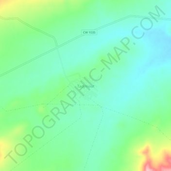
Name: tadjmout topographic map, elevation, terrain.
Location: tadjmout, Aïn Tallout, Daïra Aïn Tallout, Tlemcen, Algérie (34.69846 -0.96513 34.73846 -0.92513)
Average elevation: 1,027 m
Minimum elevation: 982 m
Maximum elevation: 1,146 m
Thank you for supporting this site ❤️
Make a donation
Make a donation
Gear up for your next adventure:
As an Amazon Associate, this site earns from qualifying purchases at no extra cost to you.