
Make a donation
Gear up for your next adventure:
As an Amazon Associate, this site earns from qualifying purchases at no extra cost to you.
Altnafeadh topographic map
Click on the map to display elevation.
Make a donation
Gear up for your next adventure:
As an Amazon Associate, this site earns from qualifying purchases at no extra cost to you.
About this map
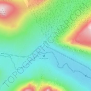
Name: Altnafeadh topographic map, elevation, terrain.
Location: Altnafeadh, Highland, Schotland, Verenigd Koninkrijk (56.65479 -4.91333 56.67479 -4.89333)
Average elevation: 398 m
Minimum elevation: 262 m
Maximum elevation: 703 m
Make a donation
Gear up for your next adventure:
As an Amazon Associate, this site earns from qualifying purchases at no extra cost to you.
Other topographic maps
Click on a map to view its topography, its elevation and its terrain.
Make a donation
Gear up for your next adventure:
As an Amazon Associate, this site earns from qualifying purchases at no extra cost to you.
Glen Etive
Verenigd Koninkrijk > Schotland > Highland
Aan de noordelijke zijde van Glen Etive liggen twee heuvels: de Buachaille Etive Mòr en de Buachaille Etive Beag. De vallei is bereikbaar via een single track road vanaf de A82 ter hoogte van Kingshouse Hotel. De weg eindigt na ongeveer 18 km, als hij Loch Etive bereikt, bij de mobiele pier in Gualachulein.…
Average elevation: 477 m
Make a donation
Gear up for your next adventure:
As an Amazon Associate, this site earns from qualifying purchases at no extra cost to you.