Geolocate

Beber topographic map

Click on the map to display elevation.

About this map

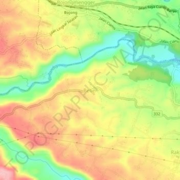
Name: Beber topographic map, elevation, terrain.

Location: Beber, Ciamis, West Java, Java, 46281, Indonesia (-7.38593 108.41461 -7.34593 108.45461)

Average elevation: 125 m

Minimum elevation: 41 m

Maximum elevation: 200 m

Other topographic maps

Click on a map to view its topography, its elevation and its terrain.

Ciamis

Indonesia > West Java > Ciamis

Ciamis Regency consists of 328 villages, with the topography predominantly characterized by 153 villages in the plains, 162 villages on the slopes, and 13 villages in the Watershed (DAS) area.

Average elevation: 217 m

Linggasari

Indonesia > West Java > Ciamis > Ciamis

Average elevation: 218 m

Bojongmengger

Indonesia > West Java > Ciamis

Average elevation: 118 m

Cikoneng

Indonesia > West Java > Ciamis

Average elevation: 492 m

Gear up for your next adventure:

💧Hydration Pack - Hands-free hydration system for long hikes
🧢Sun Hat - Wide-brim hat for sun protection
🛏️Camping Sleeping Mat - Comfortable mats for sleeping outdoors
Lightweight Camping Tent - Portable shelter optimized for Canadian backcountry camping
🧭GPS Outdoor Watch - Smart watch for navigation and fitness tracking in nature

As an Amazon Associate, this site earns from qualifying purchases at no extra cost to you.