
Make a donation
Gear up for your next adventure:
As an Amazon Associate, this site earns from qualifying purchases at no extra cost to you.
Pic de Bertagne topographic map
Click on the map to display elevation.
Make a donation
Gear up for your next adventure:
As an Amazon Associate, this site earns from qualifying purchases at no extra cost to you.
Pic de Bertagne
Le pic de Bertagne (en occitan provençal : Bauç de Bertanha selon la norme classique et Baus de Bertagno selon la norme mistralienne) est le point culminant des Bouches-du-Rhône. Le sommet culmine à 1 042 m d'altitude. Il fait partie du massif de la Sainte-Baume.
Make a donation
Gear up for your next adventure:
As an Amazon Associate, this site earns from qualifying purchases at no extra cost to you.
About this map
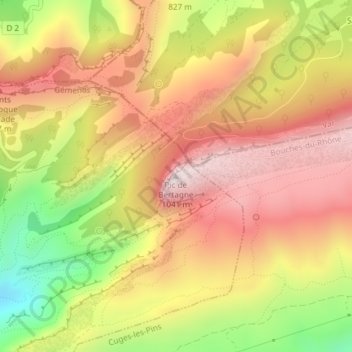
Name: Pic de Bertagne topographic map, elevation, terrain.
Average elevation: 752 m
Minimum elevation: 356 m
Maximum elevation: 1,042 m
Make a donation
Gear up for your next adventure:
As an Amazon Associate, this site earns from qualifying purchases at no extra cost to you.
Other topographic maps
Click on a map to view its topography, its elevation and its terrain.