Geolocate

Chirala topographic map

Click on the map to display elevation.

About this map

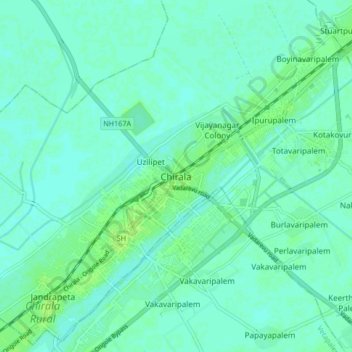
Name: Chirala topographic map, elevation, terrain.

Location: Chirala, Bapatla, Andhra Pradesh, 523155, India (15.79615 80.32366 15.87615 80.40366)

Average elevation: 5 m

Minimum elevation: 1 m

Maximum elevation: 11 m

Gear up for your next adventure:

🧴Outdoor Sunscreen - High SPF protection for high-altitude UV exposure
🥾Trail Running Shoes - Lightweight and durable shoes for trail running
🛶Waterproof Dry Bags - Keep electronics and clothes dry during river crossings
🥾Approach Shoes - Shoes designed for climbing approaches and rugged trails
🥾Trail Hiking Shoes - Durable shoes designed for rugged trails

As an Amazon Associate, this site earns from qualifying purchases at no extra cost to you.