
Make a donation
Gear up for your next adventure:
As an Amazon Associate, this site earns from qualifying purchases at no extra cost to you.
Newmarket topographic map
Click on the map to display elevation.
Make a donation
Gear up for your next adventure:
As an Amazon Associate, this site earns from qualifying purchases at no extra cost to you.
Newmarket
Situated beside Great Bay in southeastern New Hampshire, Newmarket is drained by the Lamprey River and its tributary, the Piscassic River. The town's highest point is the summit of Bald Hill, at 281 feet (86 m) above sea level, near the town's southwestern corner. Great Hill, with an elevation of 228 feet (69 m), rises just south of the town center.
Make a donation
Gear up for your next adventure:
As an Amazon Associate, this site earns from qualifying purchases at no extra cost to you.
About this map
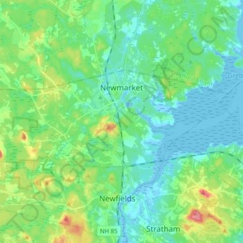
Name: Newmarket topographic map, elevation, terrain.
Average elevation: 21 m
Minimum elevation: -8 m
Maximum elevation: 84 m
Make a donation
Gear up for your next adventure:
As an Amazon Associate, this site earns from qualifying purchases at no extra cost to you.
Other topographic maps
Click on a map to view its topography, its elevation and its terrain.
Make a donation
Gear up for your next adventure:
As an Amazon Associate, this site earns from qualifying purchases at no extra cost to you.
South Beacon Shoal
United States > New Hampshire > Rockingham County > Portsmouth
Average elevation: 4 m
Hampton River
United States > New Hampshire > Rockingham County > Hampton Falls
Average elevation: 1 m
Make a donation
Gear up for your next adventure:
As an Amazon Associate, this site earns from qualifying purchases at no extra cost to you.
Make a donation
Gear up for your next adventure:
As an Amazon Associate, this site earns from qualifying purchases at no extra cost to you.
Rye Beach Village District
United States > New Hampshire > Rockingham County > Rye Beach Village District
Average elevation: 7 m
Salem Depot
United States > New Hampshire > Rockingham County > Salem > Salem Depot
Average elevation: 50 m
Make a donation
Gear up for your next adventure:
As an Amazon Associate, this site earns from qualifying purchases at no extra cost to you.