
Make a donation
Gear up for your next adventure:
As an Amazon Associate, this site earns from qualifying purchases at no extra cost to you.
Hoher Peißenberg topographic map
Click on the map to display elevation.
Make a donation
Gear up for your next adventure:
As an Amazon Associate, this site earns from qualifying purchases at no extra cost to you.
Hoher Peißenberg
Der Hohe Peißenberg gehört in der naturräumlichen Haupteinheitengruppe Subalpines Jungmoränenland (Nr. 03), in der Haupteinheit Ammer-Loisach-Isar-Jungmoränenland (037) und in der Untereinheit Hügel- und Moorland des Ammersees (037.0) zum Naturraum Peißenbergkämme (037.09). Seine Landschaft fällt etwa Nordnordosten in den Naturraum Wessobrunner Höhen (037.04) ab und nach Nordwesten über Westen bis Süden in den Naturraum Windacher Hügel (037.03).
Make a donation
Gear up for your next adventure:
As an Amazon Associate, this site earns from qualifying purchases at no extra cost to you.
About this map
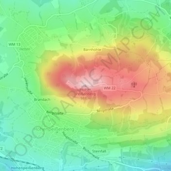
Name: Hoher Peißenberg topographic map, elevation, terrain.
Average elevation: 810 m
Minimum elevation: 690 m
Maximum elevation: 986 m
Make a donation
Gear up for your next adventure:
As an Amazon Associate, this site earns from qualifying purchases at no extra cost to you.