Geolocate

Mangagoy topographic map

Click on the map to display elevation.

About this map
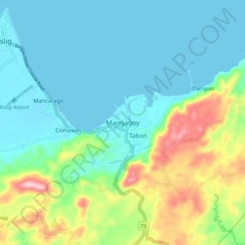
Name: Mangagoy topographic map, elevation, terrain.

Location: Mangagoy, Bislig, Surigao del Sur, Caraga, 8311, Philippines (8.16642 126.33530 8.20642 126.37530)

Average elevation: 46 m

Minimum elevation: -1 m

Maximum elevation: 231 m

Other topographic maps

Click on a map to view its topography, its elevation and its terrain.
Gear up for your next adventure:

💧Hydration Pack - Hands-free hydration system for long hikes
🎒Fully Waterproof Backpack - Total protection for photography gear and electronics
💡Compact LED Flashlight - Powerful and portable flashlight for outdoor use
🐕Hiking Dog Pack - Let your canine companion carry their own water and food
🩹Moleskin Blister Pads - Direct protection for painful foot pressure points

As an Amazon Associate, this site earns from qualifying purchases at no extra cost to you.