
Thank you for supporting this site ❤️
Make a donation
Make a donation
Gear up for your next adventure:
As an Amazon Associate, this site earns from qualifying purchases at no extra cost to you.
Bouwel topographic map
Click on the map to display elevation.
Thank you for supporting this site ❤️
Make a donation
Make a donation
Gear up for your next adventure:
As an Amazon Associate, this site earns from qualifying purchases at no extra cost to you.
Bouwel
Bouwel ligt in de Kempen op ongeveer 10 meter hoogte. De plaats ligt ten zuiden van het Albertkanaal. Ten noordwesten van de kom stroomt de Kleine Nete onder dit kanaal door. Bouwel kent de volgende natuurgebieden.
Thank you for supporting this site ❤️
Make a donation
Make a donation
Gear up for your next adventure:
As an Amazon Associate, this site earns from qualifying purchases at no extra cost to you.
About this map
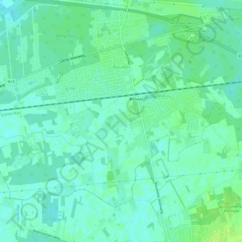
Name: Bouwel topographic map, elevation, terrain.
Average elevation: 9 m
Minimum elevation: 4 m
Maximum elevation: 16 m
Thank you for supporting this site ❤️
Make a donation
Make a donation
Gear up for your next adventure:
As an Amazon Associate, this site earns from qualifying purchases at no extra cost to you.