
Make a donation
Gear up for your next adventure:
As an Amazon Associate, this site earns from qualifying purchases at no extra cost to you.
Lago Ranco topographic map
Click on the map to display elevation.
Make a donation
Gear up for your next adventure:
As an Amazon Associate, this site earns from qualifying purchases at no extra cost to you.
Lago Ranco
Three types of very different climates can be found in Lago Ranco: the so-called rainy temperate climate with Mediterranean influence (Cfsb) mountain weather (G) and icy climate by the effect of height (EFH). The first type of climate is developed between the Cordillera Pre - Andean Middle surrounding the Depression. Not to be characterized by a dry season rainfall occurring throughout the year, presenting however some features of a break during the warm season rainfall. In this temperate rainforest does not have large temperature swings. This is facilitated by the liquid surface of Lake Ranco, moreover, prevents frost on its banks. During the spring and summer there is a persistent cloudiness that tends to dissipate by noon, which is known as South negro. The mountain climate is evident in the Andes, in some sectors of the foothills. It is above curve at 500 m, height corresponding approximately to the development of 5 °C isotherm in the coldest month and even that disappears where tree-like vegetation, the effect of low temperatures. The third type of weather that occurs in the town of Lake Ranco is the icy climate by the effect of height, which takes place in high mountain areas, where the elevation exceeds 3,000 m, the conditions in such sectors are broken between a climate of tundra, no trees, to a climate of perpetual snow without vegetation with increasing altitude.
Make a donation
Gear up for your next adventure:
As an Amazon Associate, this site earns from qualifying purchases at no extra cost to you.
About this map
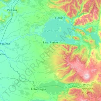
Name: Lago Ranco topographic map, elevation, terrain.
Location: Lago Ranco, Provincia de Ranco, Los Ríos Region, Chile (-40.58308 -72.68392 -40.18728 -71.65607)
Average elevation: 423 m
Minimum elevation: 15 m
Maximum elevation: 2,170 m
Make a donation
Gear up for your next adventure:
As an Amazon Associate, this site earns from qualifying purchases at no extra cost to you.