Geolocate

Pinehurst topographic map

Click on the map to display elevation.

About this map
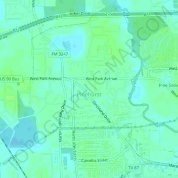
Name: Pinehurst topographic map, elevation, terrain.

Location: Pinehurst, Orange County, Texas, United States (30.09367 -93.78644 30.12250 -93.74962)

Average elevation: 5 m

Minimum elevation: 1 m

Maximum elevation: 9 m

Other topographic maps

Click on a map to view its topography, its elevation and its terrain.

Toledo Bend

United States > Texas > Orange County

Average elevation: 4 m

Connell

United States > Texas > Orange County

Average elevation: 5 m

Reese

United States > Texas > Orange County

Average elevation: 7 m

Cove

United States > Texas > Orange County > Orange

Average elevation: 3 m

Lemonville

United States > Texas > Orange County

Average elevation: 7 m

Brownwood

United States > Texas > Orange County > Orange

Average elevation: 4 m

Gear up for your next adventure:

🥾Durable Hiking Shoes - Long-lasting shoes for frequent hiking
🥽Outdoor Goggles - Protective eyewear for outdoor activities
💧Filtered Water Bottle - Safe drinking water on the go
🧥Thermal Fleece Jacket - Versatile insulation for changing mountain temperatures
🛰️Satellite Messenger - Emergency communication for areas with no cell service

As an Amazon Associate, this site earns from qualifying purchases at no extra cost to you.