Geolocate

Hewitt topographic map

Click on the map to display elevation.

About this map
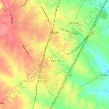
Name: Hewitt topographic map, elevation, terrain.

Location: Hewitt, McLennan County, Texas, 76643, United States (31.41429 -97.21849 31.48264 -97.16902)

Average elevation: 190 m

Minimum elevation: 150 m

Maximum elevation: 225 m

Other topographic maps

Click on a map to view its topography, its elevation and its terrain.
Elm Mott

United States > Texas > McLennan County

Average elevation: 156 m

South Bosque

United States > Texas > McLennan County > Waco

Average elevation: 161 m

Cameron Park

United States > Texas > McLennan County > Waco

Average elevation: 137 m

Waco

United States > Texas > McLennan County > Waco

Average elevation: 150 m

Hewitt

United States > Texas > McLennan County > Hewitt > Hewitt

Average elevation: 189 m

Bruceville-Eddy

United States > Texas > McLennan County

Average elevation: 198 m

Gear up for your next adventure:

🥾Waterproof Trail Shoes - Shoes designed to handle wet terrain
🧥Fleece Jacket - Warm and lightweight jacket for layering
🎒Backpack Rain Cover - External shield to keep your entire pack dry
🥾Light Trekking Boots - Supportive boots for multi-day treks
🧤Thermal Hiking Gloves - Grip-enhanced gloves for cold-weather altitude trekking

As an Amazon Associate, this site earns from qualifying purchases at no extra cost to you.