Geolocate

Symphony Lake topographic map

Click on the map to display elevation.

About this map
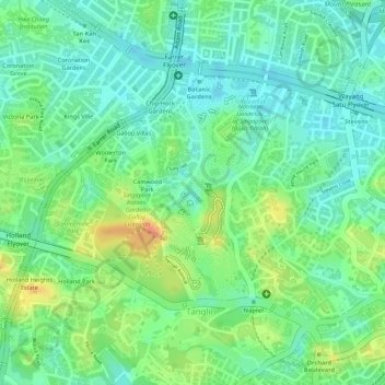
Name: Symphony Lake topographic map, elevation, terrain.

Location: Symphony Lake, Camwood Park, Tanglin, Singapore, Central, Singapore (1.31357 103.81423 1.31508 103.81521)

Average elevation: 22 m

Minimum elevation: 2 m

Maximum elevation: 53 m

Other topographic maps

Click on a map to view its topography, its elevation and its terrain.

Fort Canning Park

Singapore > Central > Singapore

The hill has a long history intertwined with that of the country due to its location as the highest elevation within walking distance to the city's civic district, within the Downtown Core. It is also a popular location for exhibitions, concerts and outdoor recreation.

Average elevation: 19 m

Kallang Basin

Singapore > Central > Singapore

Average elevation: 9 m

Pearl's Hill City Park

Singapore > Central > Singapore

Average elevation: 18 m

Lilac Drive Playground

Singapore > Central > Singapore

Average elevation: 20 m

Gear up for your next adventure:

🕶️Polarized Sunglasses - Reduces glare from snow and water at high elevations
👖Convertible Hiking Pants - Zip-off legs to adapt to changing weather conditions
🐕Hiking Dog Pack - Let your canine companion carry their own water and food
🩹Compact First Aid Kit - Pre-packed essentials for common trail injuries
🚲Handlebar Phone Mount - View topographic-map.com live while cycling

As an Amazon Associate, this site earns from qualifying purchases at no extra cost to you.