Geolocate

Karlstad topographic map

Click on the map to display elevation.

About this map

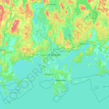
Name: Karlstad topographic map, elevation, terrain.

Location: Karlstad, Karlstads kommun, Värmland County, 652 24, Sweden (59.22091 13.34276 59.54091 13.66276)

Average elevation: 61 m

Minimum elevation: 40 m

Maximum elevation: 165 m

Other topographic maps

Click on a map to view its topography, its elevation and its terrain.

Arvika kommun

Sweden > Värmland County

Average elevation: 182 m

Gear up for your next adventure:

🧭Orienteering Kit - Tools for map reading and navigation in the wild
🧭GPS Handheld Device - Reliable GPS navigation for outdoor adventures
🧢Hiking Sun Hat - Wide-brimmed protection for exposed mountain ridges
🔭Compact Monocular - One-handed bird watching and trail spotting
🥾Mountain Trail Shoes - High-traction shoes for mountain trails

As an Amazon Associate, this site earns from qualifying purchases at no extra cost to you.