
Thank you for supporting this site ❤️
Make a donation
Make a donation
Gear up for your next adventure:
As an Amazon Associate, this site earns from qualifying purchases at no extra cost to you.
Stepps topographic map
Click on the map to display elevation.
Thank you for supporting this site ❤️
Make a donation
Make a donation
Gear up for your next adventure:
As an Amazon Associate, this site earns from qualifying purchases at no extra cost to you.
About this map
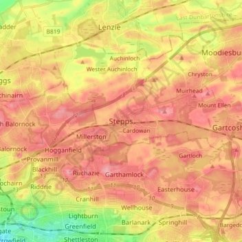
Name: Stepps topographic map, elevation, terrain.
Location: Stepps, North Lanarkshire, Scotland, G33 6HB, United Kingdom (55.85090 -4.18598 55.93090 -4.10598)
Average elevation: 73 m
Minimum elevation: 12 m
Maximum elevation: 111 m
Thank you for supporting this site ❤️
Make a donation
Make a donation
Gear up for your next adventure:
As an Amazon Associate, this site earns from qualifying purchases at no extra cost to you.