Geolocate

Tandes topographic map

Click on the map to display elevation.

About this map
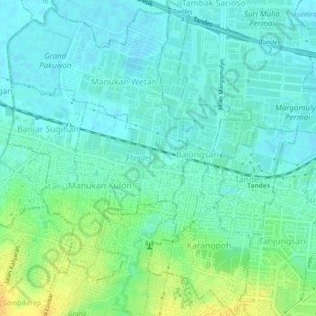
Name: Tandes topographic map, elevation, terrain.

Location: Tandes, Surabaya, East Java, 60185, Indonesia (-7.27687 112.65440 -7.23618 112.69207)

Average elevation: 9 m

Minimum elevation: 0 m

Maximum elevation: 28 m

Other topographic maps

Click on a map to view its topography, its elevation and its terrain.
Caribbean Island

Indonesia > East Java > Surabaya > Keputih

Average elevation: 0 m

Taman Harmoni

Indonesia > East Java > Surabaya

Average elevation: 2 m

Taman Flora

Indonesia > East Java > Surabaya > Baratajaya

Average elevation: 5 m

Taman Suroboyo

Indonesia > East Java > Surabaya

Average elevation: 1 m

Caribbean Island

Indonesia > East Java > Surabaya

Average elevation: 0 m

Canberra

Indonesia > East Java > Surabaya > Manukan Wetan

Average elevation: 4 m

Taman Pelangi

Indonesia > East Java > Surabaya > Gayungan

Average elevation: 6 m

Gear up for your next adventure:

🌬️Windproof Camp Stove - Efficient cooking even on exposed mountain peaks
🧰Survival Kit - Essential gear for emergencies in the wilderness
💡Portable Camping Lamp - Rechargeable lamp for campsite lighting
🧊Insulated Water Bottle - Keeps drinks cold in summer and prevents freezing in winter
🪑Insulated Seat Pad - Protect your seat from cold rocks and wet logs

As an Amazon Associate, this site earns from qualifying purchases at no extra cost to you.