Geolocate

Tablones topographic map

Click on the map to display elevation.

About this map

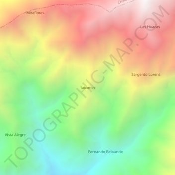
Name: Tablones topographic map, elevation, terrain.

Location: Tablones, Yamango, Morropón, Piura, Perú (-5.12039 -79.75169 -5.08039 -79.71169)

Average elevation: 2,303 m

Minimum elevation: 1,497 m

Maximum elevation: 3,215 m

Gear up for your next adventure:

🔦UV Flashlight - Detect minerals or specific insects in the dark
🔦LED Headlamp - Hands-free lighting for early morning starts or late finishes
🥾Light Hiking Boots - Lightweight and comfortable boots for day hikes
💡Portable Camping Lamp - Rechargeable lamp for campsite lighting
🧦Thermal Socks - Warm socks for winter hiking or camping

As an Amazon Associate, this site earns from qualifying purchases at no extra cost to you.