Geolocate

Ellecom topographic map

Click on the map to display elevation.

About this map

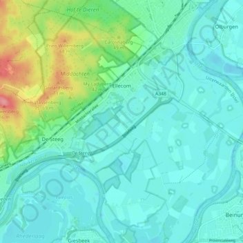
Name: Ellecom topographic map, elevation, terrain.

Location: Ellecom, Rheden, Gelderland, Netherlands (51.99634 6.05101 52.05135 6.13228)

Average elevation: 21 m

Minimum elevation: 2 m

Maximum elevation: 92 m

Other topographic maps

Click on a map to view its topography, its elevation and its terrain.

Elden

Netherlands > Gelderland > Arnhem

Average elevation: 11 m

Slingeplas

Netherlands > Gelderland > Bredevoort

Average elevation: 29 m

Veldhoek

Netherlands > Gelderland

Average elevation: 18 m

Zwin

Netherlands > Gelderland > Bern > Bern

Average elevation: 3 m

Ubbergen

Netherlands > Gelderland > Ubbergen > Ubbergen

Average elevation: 32 m

Arnhem

Netherlands > Gelderland > Arnhem

Average elevation: 24 m

Gear up for your next adventure:

🧥Softshell Hiking Jacket - The perfect balance of wind protection and breathability
🧳Compression Sacks - Maximize space in your backpack by shrinking gear
🔋Solar Power Bank - Keep your GPS and devices charged during long outdoor trips
🧭GPS Outdoor Watch - Smart watch for navigation and fitness tracking in nature
🧢Outdoor Visor - Breathable visor for sunny hikes

As an Amazon Associate, this site earns from qualifying purchases at no extra cost to you.