
Make a donation
Gear up for your next adventure:
As an Amazon Associate, this site earns from qualifying purchases at no extra cost to you.
Muotathal topographic map
Click on the map to display elevation.
Make a donation
Gear up for your next adventure:
As an Amazon Associate, this site earns from qualifying purchases at no extra cost to you.
Muotathal
Die Gemeinde liegt auf einer Höhe von 610 m ü. M. und bildet den südöstlichen Teil des Kantons Schwyz, grenzt im Süden an den Kanton Uri und im Osten an den Kanton Glarus. Mit 172 km² zählt Muotathal zu den zehn flächenmässig grössten Gemeinden der Schweiz und ist fast so gross wie der Kanton Appenzell Innerrhoden. Muotathal besteht aus den Ortschaften Muotathal, Hinterthal, Bisisthal und Ried.
Make a donation
Gear up for your next adventure:
As an Amazon Associate, this site earns from qualifying purchases at no extra cost to you.
About this map
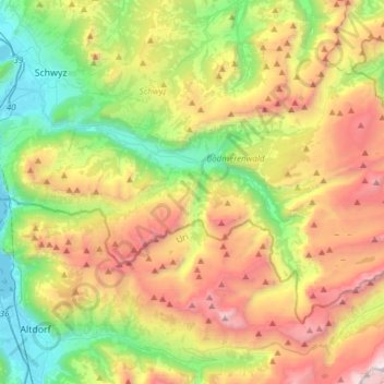
Name: Muotathal topographic map, elevation, terrain.
Location: Muotathal, Schwyz, 6436, Schweiz (46.88529 8.66729 47.02694 8.97164)
Average elevation: 1,439 m
Minimum elevation: 430 m
Maximum elevation: 2,960 m
Make a donation
Gear up for your next adventure:
As an Amazon Associate, this site earns from qualifying purchases at no extra cost to you.
Other topographic maps
Click on a map to view its topography, its elevation and its terrain.
Rigi
Schweiz > Schwyz > Schwyz > Arth
Die Rigi, auch der Rigi, ist ein Bergmassiv zwischen dem Vierwaldstättersee, dem Zugersee und dem Lauerzersee in der Zentralschweiz. Höchster Gipfel ist mit einer Höhe von 1797,5 m ü. M. Rigi Kulm, ein beliebtes Ausflugsziel für Touristen. Etwas weniger hoch sind die weiteren Gipfel Rigi Hoflue, Dossen,…
Average elevation: 1,266 m
Make a donation
Gear up for your next adventure:
As an Amazon Associate, this site earns from qualifying purchases at no extra cost to you.
Rigi
Schweiz > Schwyz > Schwyz > Arth
Die Rigi, auch der Rigi, ist ein Bergmassiv zwischen dem Vierwaldstättersee, dem Zugersee und dem Lauerzersee in der Zentralschweiz. Höchster Gipfel ist mit einer Höhe von 1797 m ü. M. Rigi Kulm, ein beliebtes Ausflugsziel für Touristen. Etwas weniger hoch sind die weiteren Gipfel Rigi Hoflue, Dossen,…
Average elevation: 1,266 m
Rigi
Schweiz > Schwyz > Schwyz > Arth
Die Rigi, auch der Rigi, ist ein Bergmassiv zwischen dem Vierwaldstättersee, dem Zugersee und dem Lauerzersee in der Zentralschweiz. Höchster Gipfel ist mit einer Höhe von 1797,5 m ü. M. Rigi Kulm, ein beliebtes Ausflugsziel für Touristen. Etwas weniger hoch sind die weiteren Gipfel Rigi Hoflue, Dossen,…
Average elevation: 1,266 m
Goldau
Wenn man vom Goldauer Bergsturz redet, so ist meist jener des Jahres 1806 gemeint, obschon insgesamt etwa 20 Bergstürze bekannt sind und obschon für die heutige Landschaftsbildung der mittelalterliche Bergsturz von Oberarth im 14. Jahrhundert von grösserer Bedeutung war, da der Sturz grössere Felsbrocken…
Average elevation: 856 m
Make a donation
Gear up for your next adventure:
As an Amazon Associate, this site earns from qualifying purchases at no extra cost to you.
Stoos
Stoos (meist der Stoos genannt) ist ein autofreies Dorf und Skigebiet auf dem Gebiet der Gemeinde Morschach im Schweizer Kanton Schwyz. Das Dorf liegt in 1305 m ü. M. Höhe auf einem Hochplateau. Es hat 150 Einwohner und 2200 Gästebetten. Das Skigebiet reicht bis in eine Höhe von 1935 m ü. M.
Average elevation: 1,232 m
Make a donation
Gear up for your next adventure:
As an Amazon Associate, this site earns from qualifying purchases at no extra cost to you.
Make a donation
Gear up for your next adventure:
As an Amazon Associate, this site earns from qualifying purchases at no extra cost to you.