
Make a donation
Gear up for your next adventure:
As an Amazon Associate, this site earns from qualifying purchases at no extra cost to you.
Croix de Beliou topographic map
Click on the map to display elevation.
Make a donation
Gear up for your next adventure:
As an Amazon Associate, this site earns from qualifying purchases at no extra cost to you.
About this map
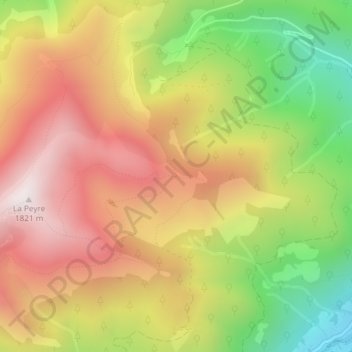
Name: Croix de Beliou topographic map, elevation, terrain.
Average elevation: 1,349 m
Minimum elevation: 811 m
Maximum elevation: 1,813 m
Make a donation
Gear up for your next adventure:
As an Amazon Associate, this site earns from qualifying purchases at no extra cost to you.
Other topographic maps
Click on a map to view its topography, its elevation and its terrain.
Réservoir des Laquets
France > Occitanie > Hautes-Pyrénées > Bagnères-de-Bigorre
Average elevation: 2,139 m
Télescope Bernard Lyot
France > Occitanie > Hautes-Pyrénées > Bagnères-de-Bigorre
Average elevation: 2,278 m
Make a donation
Gear up for your next adventure:
As an Amazon Associate, this site earns from qualifying purchases at no extra cost to you.