
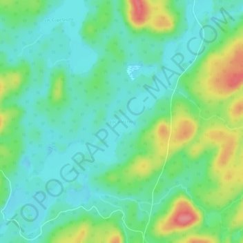
Lac Winchell topographic map
Interactive map
Click on the map to display elevation.
About this map
Name: Lac Winchell topographic map, elevation, terrain.
Average elevation: 427 m
Minimum elevation: 401 m
Maximum elevation: 487 m
Other topographic maps
Click on a map to view its topography, its elevation and its terrain.
Lac-Lenôtre
Canada > Québec > Lac-Lenôtre
Lac-Lenôtre, La Vallée-de-la-Gatineau, Outaouais, Québec, Canada
Average elevation: 404 m
Lac Wapus
Canada > Québec > Lac-Lenôtre
Lac Wapus, Lac-Lenôtre, La Vallée-de-la-Gatineau, Outaouais, Québec, Canada
Average elevation: 416 m
Lac Pikianikijuan
Canada > Québec > Lac-Lenôtre
Lac Pikianikijuan, Lac-Lenôtre, La Vallée-de-la-Gatineau, Outaouais, Québec, Canada
Average elevation: 379 m
Lac Haire
Canada > Québec > Lac-Lenôtre
Lac Haire, Lac-Lenôtre, La Vallée-de-la-Gatineau, Outaouais, Québec, Canada
Average elevation: 470 m
Lac Christina
Canada > Québec > Lac-Lenôtre
Lac Christina, Lac-Lenôtre, La Vallée-de-la-Gatineau, Outaouais, Québec, Canada
Average elevation: 402 m
Lac Landron
Canada > Québec > Lac-Lenôtre
Lac Landron, R0713, Lac-Lenôtre, La Vallée-de-l'Or, Outaouais, Québec, Canada
Average elevation: 369 m
Lac Lyon
Canada > Québec > Lac-Lenôtre
Lac Lyon, Lac-Lenôtre, La Vallée-de-la-Gatineau, Outaouais, Québec, Canada
Average elevation: 438 m
Rivière Cabonga
Canada > Québec > Lac-Lenôtre
Rivière Cabonga, Lac-Lenôtre, La Vallée-de-la-Gatineau, Outaouais, Québec, Canada
Average elevation: 398 m