
Make a donation
Gear up for your next adventure:
As an Amazon Associate, this site earns from qualifying purchases at no extra cost to you.
Awka topographic map
Click on the map to display elevation.
Make a donation
Gear up for your next adventure:
As an Amazon Associate, this site earns from qualifying purchases at no extra cost to you.
Awka
Awka lies below 300 metres above sea in a valley on the plains of the Mamu River. Two ridges or cuestas, both lying in a north–south direction, form the major topographical features of the area. The ridges reach the highest point at Agulu just outside the Capital Territory. About six kilometers east of this, the minor cuesta peaks about 150 metres above sea level at Ifite –Awka.
Make a donation
Gear up for your next adventure:
As an Amazon Associate, this site earns from qualifying purchases at no extra cost to you.
About this map
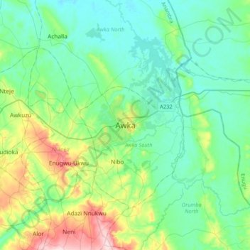
Name: Awka topographic map, elevation, terrain.
Location: Awka, Awka South, Anambra State, Nigeria (6.05895 6.91744 6.37895 7.23744)
Average elevation: 90 m
Minimum elevation: 23 m
Maximum elevation: 323 m
Make a donation
Gear up for your next adventure:
As an Amazon Associate, this site earns from qualifying purchases at no extra cost to you.