Geolocate

Geneva topographic map

Click on the map to display elevation.

About this map
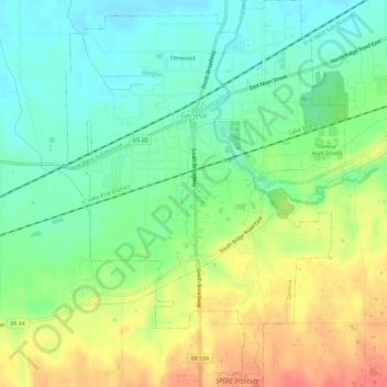
Name: Geneva topographic map, elevation, terrain.

Location: Geneva, Geneva Township, Ashtabula County, Ohio, 44041, United States (41.77945 -80.96701 41.81818 -80.92473)

Average elevation: 213 m

Minimum elevation: 191 m

Maximum elevation: 243 m

Other topographic maps

Click on a map to view its topography, its elevation and its terrain.
Pierpont

United States > Ohio > Ashtabula County

Average elevation: 305 m

Chapel

United States > Ohio > Ashtabula County

Average elevation: 258 m

Phelps Creek

United States > Ohio > Ashtabula County

Average elevation: 326 m

Pierpont

United States > Ohio > Ashtabula County

Average elevation: 305 m

Gear up for your next adventure:

🧢Sun Protection Cap - Breathable cap to protect from sun exposure
⛺Bushcraft Tarp - Versatile emergency shelter or gear protection
🥾Trail Running Shoes - Lightweight and durable shoes for trail running
🧭Orienteering Kit - Tools for map reading and navigation in the wild
⛺Backpacking Tent - Lightweight tent for long-distance hiking trips

As an Amazon Associate, this site earns from qualifying purchases at no extra cost to you.