
Dren topographic map
Click on the map to display elevation.
About this map
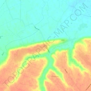
Name: Dren topographic map, elevation, terrain.
Average elevation: 98 m
Minimum elevation: 77 m
Maximum elevation: 123 m
Other topographic maps
Click on a map to view its topography, its elevation and its terrain.
Drazevac
Serbia > Central Serbia > City of Belgrade > Obrenovac Urban Municipality
Average elevation: 115 m
Mala Mostanica
Serbia > Central Serbia > City of Belgrade > Obrenovac Urban Municipality
Average elevation: 155 m
Grabovac
Serbia > Central Serbia > City of Belgrade > Obrenovac Urban Municipality
Average elevation: 91 m
Orasac
Serbia > Central Serbia > City of Belgrade > Obrenovac Urban Municipality
Average elevation: 115 m