
Make a donation
Gear up for your next adventure:
As an Amazon Associate, this site earns from qualifying purchases at no extra cost to you.
Grand Charnier topographic map
Click on the map to display elevation.
Make a donation
Gear up for your next adventure:
As an Amazon Associate, this site earns from qualifying purchases at no extra cost to you.
About this map
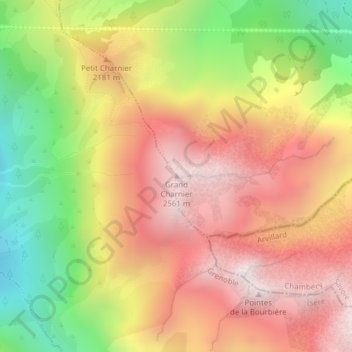
Name: Grand Charnier topographic map, elevation, terrain.
Average elevation: 2,005 m
Minimum elevation: 1,304 m
Maximum elevation: 2,573 m
Make a donation
Gear up for your next adventure:
As an Amazon Associate, this site earns from qualifying purchases at no extra cost to you.
Other topographic maps
Click on a map to view its topography, its elevation and its terrain.
La Chapelle-du-Bard
France > Auvergne-Rhône-Alpes > Isère > La Chapelle-du-Bard
Commune rurale de montagne étagée de 343 m d'altitude au confluent du Bréda et du Bens à 2 561 m d'altitude au Grand Charnier, traversée par le torrent Le Bard et limitée par le ruisseau du Buisson, qui forme la cascade de la Pierre Tombante,et le Bens respectivement côté commune d'Allevard et côté…
Average elevation: 938 m