Geolocate

Cancún topographic map

Interactive map

Click on the map to display elevation.

Cancún topographic map, elevation, terrain

Cancún topographic map, elevation, terrain

About this map

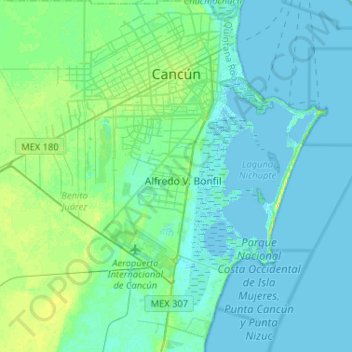
Name: Cancún topographic map, elevation, terrain.

Location: Cancún, Benito Juárez, Quintana Roo, Mexico (20.97059 -86.99562 21.21238 -86.74053)

Average elevation: 5 m

Minimum elevation: -4 m

Maximum elevation: 21 m

Other topographic maps

Click on a map to view its topography, its elevation and its terrain.

Tulum

Mexico > Quintana Roo > Tulum

Average elevation: 2 m

Isla Mujeres

Mexico > Quintana Roo

Average elevation: 3 m

Playa del Carmen

Mexico > Quintana Roo

Average elevation: 5 m

Benito Juárez

Mexico > Quintana Roo > Benito Juárez

In response to the French invasion and the elevation of Maximilian as Emperor of Mexico, Juárez sent General Plácido Vega y Daza to California to gather Mexican American sympathy for republican Mexico. Maximilian offered Juárez amnesty and later the post of prime minister, but Juárez refused to accept a…

Average elevation: 7 m

Cozumel

Mexico > Quintana Roo

Large parts of the island are covered with mangrove forest which has many endemic animal species. Cozumel is a flat island based on limestone, resulting in a karst topography. The highest natural point on the island is less than 15 m (49 ft) above sea level. The cenotes are deep water-filled sinkholes formed…

Average elevation: 1 m

Cancún

Mexico > Quintana Roo > Benito Juárez

Average elevation: 5 m

Guadalupe

Mexico > Quintana Roo > Guadalupe

Average elevation: 22 m